Greenside, Cleaner – Greener – Safer
The Community consists of:
- The permanent and temporary residents of Greenside.
- The community at large.
- Environmentalists and urban planners who are concerned with the under-utilization of public green spaces in Johannesburg.
- NGOs, corporates, local businesses and government bodies (City Parks) who have a
vested interest in re-connecting the Greenside neighborhood and the rest of Johannesburg to
this neglected piece of heritage through design, education and outreach. To use it as a catalyst
to build social cohesion across communities, to develop skills among the unemployed, to
educate residents about environmental issues, to beautify public space and to champion
unused or under-utilized green spaces in the greater Johannesburg area. - The inspiration for the park was derived from the nature and culture inherent in Greenside: youthful,
playful, diverse and environmentally conscious. A park which would ultimately represent a contemporary
responsive design. The vision is one that incorporates a dynamic kaleidoscope of planting and paving
and urban sculpture encompassing the heritage of the area. - The information gathered during the community site studies has been used to inform the landscape design
strategy. The straight line pedestrian linkages and tuk-tuk movements have been used to structure the park
layout and the design concepts have been used to connect this neglected space to the rest of Greenside. - All the systems, natural and urban, and the people of Greenside were considered in order to instill a sense
of place, identity and belonging – thus encouraging people to invest in it and keep it maintained. The
ultimate product will be one that reflects a cultural photograph of South Africa, where the community
can exchange ideas and engage socially.
THE BRIEF
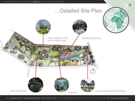
SIR LIONEL PHILLIPS PLAY AREA:
To redesign and upgrade the Sir Lionel Phillips Park and in particular to develop
concepts for a play/ jungle gym area.
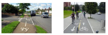
COMPLETE STREET:
To develop concepts for Greenway Street as a “Complete Street” from the old tram circle
up to Hoylake Road with a vision of introducing a cycle track, pause areas for pedestrians
with seating as well as urban sculptures and planning.
CORPORATE IDENTITY AND MEDIA SOCIAL NETWORK INTEGRATION AND MAINTENANCE:
To provide a sustainable and responsible brand design and to develop a system for
maintaining a cohesive social media strategy for the Greenside Community.
MAPPING OVERVIEW
A map can simply be defined as a graphic and visual representation of a certain
area or town. This visual representation includes a variety of information that comprises of all
aspects of a complete street. Our mapping can guided our evaluation and
planning of our project.
The movement and transport group created visual representations of the
movement around greenside. The maps also included the routes that motorized and nonmotorized
movement uses. The maps mainly describes the ideal domain for the given focus. Our
mapping allowed us to plot the major ideas and how they are interconnected. The maps
emphasize a different part of conceptualized information, this is important to remember that they
are all related to each other but are simply reflecting different sides to our mapping concepts.
We completed the mapping task by means of planning The Complete Street elements such as
sidewalks, bike lanes, special bus lanes, comfortable and accessible public transportation stops,
safe pedestrian crossings, accessible pedestrians signals to make the environment pedestrian
friendly. The benefit of the task is to improve safety, encourage health through walking and biking,
improve social interaction within the community and creating a positive public image of Greenside
and mainly Greenway Street.
COMPLETE STREET INFO
A complete street refers to roads designed to accommodate diverse modes, users and activities including
walking, cycling, public transport, automobiles, nearby businesses and residents. a more liveable
community.
The complete street group was tasked with proposing a holistic change to Greenway Street, we
were tasked with giving options and proposals that can turn it into a complete street.
The reasoning behind this is because of the current problems and situations found on Greenway,
problems such as; a lack of paved walkways and pavement for pedestrians to walk on, conflict
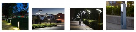
between vehicular and pedestrians movement, insufficient lighting, there are no dedicated
cycle lanes which makes cycling in general unsafe, unclear road markings and signage.
The above were some of the major problems we are faced with on Greenway, through various research and
ideas we created design interventions for each problem area.
OUR RESEARCH AND INITIAL FINDINGS
Included our background work, mapping, photos, and where we identified problem
areas
Speaking with residents, visitors, students and business owners to gauge their view
on how the street is used and how we could enhance it.
Summarized findings
Influences, references which included a review of the Johannesburg Guidelines for
creating a Complete Street including the analysis of the city planning of New York.